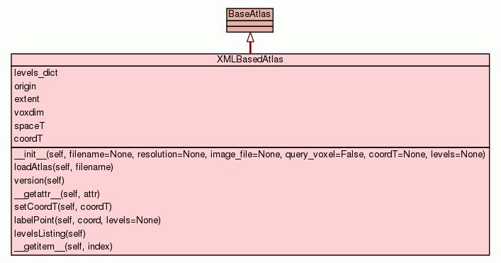
Package mvpa :: Package atlases :: Module base :: Class XMLBasedAtlas
[hide private]
[frames] | no frames]

Class XMLBasedAtlas

source code


Instance Methods [hide private]
 
__init__(self, filename=None, resolution=None, image_file=None, query_voxel=False, coordT=None, levels=None)
Create an atlas object based on the... XXX
source code
 
_checkRange(self, c)
check and adjust the voxel coordinates
source code
 
_loadImages(self)
To be overriden in the derived classes. By default does nothing
source code
 
_loadData(self)
To be overriden in the derived classes. By default does nothing
source code
 
loadAtlas(self, filename) source code
 
version(self) source code
 
__getattr__(self, attr)
Lazy way to provide access to the definitions in the atlas
source code
 
setCoordT(self, coordT)
Set coordT transformation.
source code
 
labelPoint(self, coord, levels=None)
Return labels for the given spatial point at specified levels
source code
 
levelsListing(self) source code
 
_getLevels(self, levels=None)
Helper to provide list of levels to operate on
source code
 
__getitem__(self, index)
Accessing the elements via simple indexing. Examples: print atlas[ 0, -7, 20, [1,2,3] ] print atlas[ (0, -7, 20), 1:2 ] print atlas[ (0, -7, 20) ] print atlas[ (0, -7, 20), : ]
source code
 
_getLevelsDict(self) source code
 
_getLevelsDict_virtual(self) source code

Inherited from object: __delattr__, __format__, __getattribute__, __hash__, __new__, __reduce__, __reduce_ex__, __repr__, __setattr__, __sizeof__, __str__, __subclasshook__

Static Methods [hide private]
 
_checkVersion(version)
To be overriden in the derived classes. By default anything is good
source code
 
_compare_lists(checkitems, neededitems) source code
 
_children_tags(root) source code
Class Variables [hide private]
  levels_dict = property(fget= _getLevelsDict)
  origin = property(fget= lambda self: self._origin)
  extent = property(fget= lambda self: self._extent)
  voxdim = property(fget= lambda self: self._voxdim)
  spaceT = property(fget= lambda self: self._spaceT)
  coordT = property(fget= lambda self: self._spaceT, fset= setCo...
Properties [hide private]

Inherited from object: __class__

Method Details [hide private]

__init__(self, filename=None, resolution=None, image_file=None, query_voxel=False, coordT=None, levels=None)
(Constructor)

source code 
Create an atlas object based on the... XXX
Parameters:
  • filename (string) - Filename for the xml definition of the atlas
  • resolution (None or float) - Some atlases link to multiple images at different resolutions. if None -- best resolution is selected using 0th dimension resolution
  • image_file (None or str) - If None, overrides filename for the used imagefile, so it could load a custom (re-registered) atlas maps
  • query_voxel (bool) - By default [x,y,z] assumes coordinates in space, but if query_voxel is True, they are assumed to be voxel coordinates
  • coordT - Optional transformation to apply first
  • levels (None or slice or list of int) - What levels by default to operate on
Overrides: object.__init__

version(self)

source code 
Decorators:
  • @property

setCoordT(self, coordT)

source code 

Set coordT transformation.

spaceT needs to be adjusted since we glob those two transformations together

labelPoint(self, coord, levels=None)

source code 

Return labels for the given spatial point at specified levels

Function takes care about first transforming the point into the voxel space

Parameters:
  • coord (tuple) - Coordinates of the point (xyz)
  • levels (None or list of int) - At what levels to return the results

_getLevels(self, levels=None)

source code 

Helper to provide list of levels to operate on

Depends on given levels as well as self.levels


Class Variable Details [hide private]

coordT

Value:
property(fget= lambda self: self._spaceT, fset= setCoordT)